
Seven million people were under winter weather alerts Tuesday as the Plains and parts of the Midwest experience blizzard conditions that have already led to dozens of weather-related incidents over the Christmas holiday.
The "significant" winter storm with heavy snow, blizzard conditions and "potentially damaging ice" will last in the north-central part of the country through Wednesday, the National Weather Service said.
Snow was falling Tuesday at a rate of an inch an hour at times across portions of northeast Colorado, western South Dakota, western Nebraska and northwest Kansas.
The past 48 hours have already seen Douglas Pass, Colorado, pick up 13 inches of snow; Lander, Wyoming, 11.4 inches; Columbus, Nebraska, 8 inches; and the Denver metro area, 1 to 3 inches.
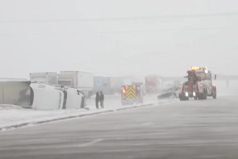
In Nebraska, troopers responded to more than 100 weather-related incidents, the state patrol said Christmas evening, describing most of them as “slide-offs and non-injury situations” due to icy roads. Photos from the travel chaos showed jackknifed semitrucks and tractor-trailers that veered off roads.
On Monday, the South Dakota Transportation Department warned that snow, freezing rain and winds created “zero visibility” conditions on the roads and Interstate 90 was closed.
















A blizzard warning is in effect through 5 a.m. local time Wednesday affecting some 600,000 people across five states, most heavily South Dakota and Nebraska, the weather service said. It predicted additional snow accumulations of 2 to 7 inches and wind gusts as high as 60 mph.
The snow and wind are part of a sprawling storm system that will bring rain to parts of the mid-Atlantic and the Southeast on Tuesday and the Northeast on Wednesday.
The snow blanketing the Rockies and the Plains, rain and storms in the East, as well as strong winds gusting upward of 55 mph in some areas, will snarl holiday travel as millions take to the skies and roads after Christmas Day.
The weather service warned that the combination of snow and whiteout conditions will make travel "difficult to impossible." Delays will likely affect major hubs such as Denver, Minneapolis, Cleveland and Charlotte, North Carolina.
Over Christmas weekend, 300 Southwest Airlines flights were canceled Sunday because of thick fog at Midway Airport, the airlines’ fourth-largest operation base, NBC Chicago reported. More than 100 additional flights were canceled on Christmas Day, but the airline said its operations were “stable” and it hoped for a “full recovery” for the post-holiday rush that kicks off Tuesday.
So far Tuesday, more than 1,700 flights have been delayed within, to or out of the U.S., and 50 were canceled, according to FlightAware data.
Rain will move into the Northeast on Wednesday and travel delays are likely at major hubs from Washington, D.C., to New York and Boston.
Rainfall from 0.5 inches to 2 inches is forecast, with locally high amounts possible, along with isolated flash flooding, in parts of the southern Appalachians of North Carolina and Virginia.
Dense fog is also blanketing the Northeast, with 37 million under dense fog advisories Tuesday morning from eastern Pennsylvania to southern Maine, with low visibility threatening airport travel delays and dangerous driving conditions in New York, Hartford, Connecticut, and Boston.
